

The World Health Organisation has depicted Union Territories – Jammu and Kashmir and Ladakh as separate from the Indian territory in a colour-coded map of countries on basis of the latest pandemic data. According to a report by ‘The Times of India’ WHO has followed all guidelines set by the United Nations.
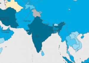
The map shows India as navy blue, whereas Jammu and Kashmir and Ladakh have been coloured grey as a separate region. The contentious border of the Aksai Chin has been marked grey with blue stripes of the same shade as the China region.